
Two things you learn quite early on if you start to do any serious trekking here in Oman.
Find old Ordinance Survey maps, they show most of the original footpaths that have been used for generations. One small caveat, two really; the position of some is only approximate and village names (English transliteration) change.
This is probably the most important: learn to recognise the path, as they can be quite obscure or even lost in the general detritus of previous storms.
In some areas they stand out like a map on the landscape; dark smooth areas on the rock that in many cases has change from rough and sharp-edged rock into glass like smoothness.
When all else fails, children and old people used these paths so if you are finding the path has suddenly become very difficult, you are not on the right route!
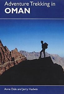
Buy this book……. Of all the new publications; it is still the best, even if a little dated now. They put a lot of hard work into getting the routes and maps as exact as possible.
See this link.

Looks like pre-historical Earth!
Awesome!
Thanks.
And struggle if you miss the path 🙂 .
David.
Amazing landscape.
Keeps me out of mischief 🙂