 Before sunrise & in the opposite direction from the earlier post I made.
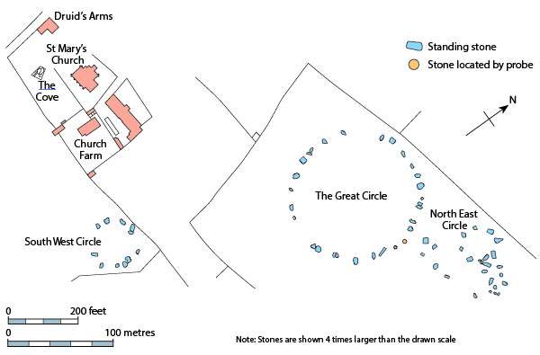
This from wikipedia & English Heritage.
Geophysical work by English Heritage in 1997 revealed a surrounding ditch and nine concentric rings of postholes within the stone circle. More than four hundred pits, 1 metre (3ft 3in) across and at 2.5 metres (8ft 2in) intervals, stood in rings at the site. The ditch is 135 metres (443ft) in diameter and about 7 metres (23ft) wide. A 40 metres (130ft) wide entrance was visible on the north-east side. No surrounding bank has been identified although the site awaits excavation.
The geophysical work transformed the traditional view of Stanton Drew as being a surface monument and the Great Circle is now seen as being one of the largest and most impressive Neolithic monuments to have been built. Analogous with the circles of postholes at sites at Woodhenge, Durrington Walls and The Sanctuary, it is thought that the pits would have held posts which would have either been freestanding or lintelled as they could not have supported a roof at that size. The postholes in nine concentric rings held posts up to 1 metre (3.3ft) in diameter indicating the use of ancient trees which were sacred to the druids.
Nearby and to the north-east is a smaller ring of eight stones in the centre of which the geophysical work identified four further pits. A third ring of twelve stones, measuring 43 metres (141 t) wide, stands to the south-west.
The Cove.
A fluxgate gradiometer survey in July 2009 investigated standing stones in the garden of the Druids Arms public house known as The Cove, which showed that the stones date from nearly a thousand years before the stone circles. The conclusion from the study was that these upright stones are likely to have been the portals or façade of a chambered tomb.

This is a half-hour drive from me 🙂 When it snowed at the beginning of Feb, I managed to drive there and take pictures (see my ‘projects’ page). Each time I go, it looks different, with the weather, the seasons… Amazing place!
You are very lucky to have it on your doorstep.
I need to spend a few days there, a lot of film could be used if the light was right. 🙂
Must look for a good Inn for a couple of night in the Autumn. Although getting dry weather in UK seems at a premium.
“Although getting dry weather in UK seems at premium.” Too true! 😀
Wow! 🙂
Pleased you like it. ☺️
It was a most enjoyable day out.
Fascinating information! The revelation that Stanton Drew may once have had a roof shows how hard it is to guess what ancient sites may have looked like simply based on visible remains. As technology continues to change how archaeological data is produced, perhaps we’ll have to reconfigure our understandings of many ancient sites and peoples.
You are right.
Satellite images of the Nile Delta area that Sarah Parcak uses, being an example.
Old maps that people think are no longer relevant being another: I was given quite a few maps from the early 1960’s of Oman that were invaluable for showing old footpaths. Most people thought I was rather strange when I kept asking for them, until I showed how newer maps didn’t show old paths and villages long forgotten.
Ultra-high resolution satellite imaging, unmanned aerial vehicle photography, and sub-surface geophysical investigation are others.
All fun stuff 🙂
Fun stuff indeed! I can’t wait to see how archaeology develops in the future.
I hadn’t thought about older maps containing treasures that have been left out of newer ones, however. I suppose both old and new sources of information have advantages!