 Stanton Drew Stone Circles – Standing stone.
Tag: Archæology site
Stanton Drew Stone Circles – Early morning.
 Stanton Drew Stone Circles – Early morning mist as moon goes down.
Stanton Drew Stone Circles – Split toned.
 Stanton Drew Stone Circles – Split toned.
Stanton Drew – Stone circles Somerset No2.
 Before sunrise & in the opposite direction from the earlier post I made.
This from wikipedia & English Heritage.
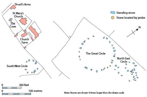
Geophysical work by English Heritage in 1997 revealed a surrounding ditch and nine concentric rings of postholes within the stone circle. More than four hundred pits, 1 metre (3ft 3in) across and at 2.5 metres (8ft 2in) intervals, stood in rings at the site. The ditch is 135 metres (443ft) in diameter and about 7 metres (23ft) wide. A 40 metres (130ft) wide entrance was visible on the north-east side. No surrounding bank has been identified although the site awaits excavation.
The geophysical work transformed the traditional view of Stanton Drew as being a surface monument and the Great Circle is now seen as being one of the largest and most impressive Neolithic monuments to have been built. Analogous with the circles of postholes at sites at Woodhenge, Durrington Walls and The Sanctuary, it is thought that the pits would have held posts which would have either been freestanding or lintelled as they could not have supported a roof at that size. The postholes in nine concentric rings held posts up to 1 metre (3.3ft) in diameter indicating the use of ancient trees which were sacred to the druids.
Nearby and to the north-east is a smaller ring of eight stones in the centre of which the geophysical work identified four further pits. A third ring of twelve stones, measuring 43 metres (141 t) wide, stands to the south-west.
The Cove.
A fluxgate gradiometer survey in July 2009 investigated standing stones in the garden of the Druids Arms public house known as The Cove, which showed that the stones date from nearly a thousand years before the stone circles. The conclusion from the study was that these upright stones are likely to have been the portals or façade of a chambered tomb.
Tower Tombs at Shir/Jaylah.
 Tower Tombs at Shir/Jaylah.
From my files: I made several visits after hearing reports by locals describing towers & later reports from a helicopter pilot who noted these strange towers while flying over the area.
See link below for a very detailed and interesting report by: Paul Yule and Gerd Weisgerber on these and other tombs in Oman. Well worth a read.
Link: Tombs in Oman.
Sentinels.
 Sentinels stand guard over a Bronze-age Archæology site.
Ruins.
 Ruins.
Khor Rori – a walk around the archæological site of Sumhuram.
")
")
")
")
")
")
")
")
")
")
Sumhuram.
A site on the coast near Mirbat Dhofar.
It has always been assumed that Sumhuram was founded in the 1st century CE, for the trade of frankincense between the Mediterranean Sea and India. The latest discoveries by archæologists from the Italian University of Pisa using pottery assemblage & C14 dating, put its foundation back to the 4th century BCE; it looks like it was an important stopping place on the trade route between south-eastern Arabia and the northern coast of Oman.
Khor Rori – Dhofar.
 Made from the hill that excavation of the archæology site of Sumhuram is being carried out – first discovered by the Yorkshire born explorer James Theodore Bent when he visited the area between 1894 & 1895.
 For his travels in the area, see the red line near Mirbat on the above map.
