
 Thick walls & no glass!
Thick walls & no glass!
 On a visit to another fort here in Oman (Al Hazm Fort) I had the services of a guide who explained the convoluted passages and in some cases dead-ends! Confusion…… If the enemy breached the gates, the rampage through the fort was impeded by indecision; this gave the defenders enough time to mount a new defence.
 This shows the different construction techniques used (Mud, straw & rock) the mud brick needs constant maintenance, otherwise it slowly disintegrate in the rains.
 One of a very large number of small Bats in Bahla Fort.
I don’t think I mentioned Bats from last weekends visit to Bahla Fort 🙂
What with the talk of Jinns and getting a little lost; there were a great number of bats, especially in the darker corners of the fort. A feeling of Transylvania about the place…..
I was determined to get a picture of one, but easier said than done ! So excuse the quality, it is a miracle of Nikon that I got one at all. The body size was about 10cm and the room needed to be dark for them to land, otherwise they were zipping round getting excited about being disturbed.
So how did I manage this image without giving them more stress?
Camera set on Auto exposure, Aperture-priority AE, 1/60 sec, f/8, ISO 200 with built-in flash set very low & using my Tokina 35-70 f2.8 lens. I stood in the room until my eyes adjusted (zone focused my lens) then waited.


 Nikon D800, Tokina 35-70 f2.8 AIs AT-X.
These made during my visit to the fort, after checking that it was open !
The village is part of the oasis of old Bahla, it developed alongside the fort and utilised the same water supply; it was also within the forts outer walls.
 I couldn’t close today after a fort visit, without at least one door….. 🙂

I have been trying to get a visit for aeons, but always closed – beginning to think it was a conspiracy by the jinns that are said to occupy the place….
Bahla fort and settlement owed its prosperity to the Banu Nebhan tribe who had prominence from the 12th to the end of the 15th century and made Bahla their capital. From here they were able to established relationships with other tribal groups of the interior. Bahla was the centre of Ibadism (a branch of Islam), on which the ancient Omani Imamates were based.
The fort became a UNESCO World Heritage Site in 1987. It was included on the List of World Heritage in Danger from 1988 and restoration work began in the 1990s. The fort with its walls and towers of mud brick on stone foundations along with the wall enclosed oasis, is understood to be the third largest example in the world. It’s a labyrinth of floors, doors and rooms; without a guide, needs careful thought as to which way the entrance was, when time for departure. 🙂
The town is well known for its pottery and although not mentioned unless one asks, its magic, in fact its second name is “Madinat Al Sehr”(the City of Magic). All part of Oman’s unwritten history of tradition and folklore.
Cannon found at the entrance.


 Old !
Old !
 Steps & Shadows No2.


This is what UNESCO say about these tombs:
The zone encompassing the settlement and necropolis of Bat is the most complete and best-known site of the 3rd millennium BC. In a restricted, coherent space, the necropolis of Bat bears characteristic and unique witness to the evolution of funeral practices during the first Bronze Age in the Oman peninsula.
Historical sources recount that the country of Magan was the principal extraction centre for copper, which was exported even to far-away Mesopotamia, as early as about 3000 BC. The appearance of a more strictly hierarchical social organization (as attested to both in the settlements, where circular defensive structures contrast with rectangular houses, and in the necropolis, where the arrangement of funerary space is more complex) goes hand in hand with higher living standards and social changes linked to a trade economy.
The protohistoric site extends north of the village and palm grove of Bat, when excavation began in 1972; it includes a settlement and a necropolis from the 3rd millennium BC. In the settlement zone, north of the confluence of a small waterway and Wadi al Hijr, there are five stone ‘towers’, structures that are very representative of the first Bronze Age in the Oman peninsula. One of the towers has been entirely excavated and it has been determined that it was built between 2595 BC and 2465 BC. At the level of the substructures, the plan of the tower features a series of exterior surface projections and two rows of parallel rooms on either side of a large platform in masonry with a well in the centre.
From the tower, which serves as the site’s reference point, can be distinguished immediately to the east on the slope a series of rectangular houses with central courts and, to the north, a vast necropolis that can be divided into two distinct groups. The first group is located at the top of the rocky slope. Its drystone tombs (some of which date from the 4th millennium, although in some cases they may have subsequently been modified) are scattered along the path from Bat to Al Wahrah.
The much more densely concentrated second group extends over rice terraces south-east of the wadi and includes more than 100 drystone ‘beehive’ tombs, which tend to be organized according to an overall plan. The most ancient ones are to the north. They have only one entrance and one funerary chamber and were a collective burial-place for a small number of dead. Towards the south, the sepulchres become more monumental. They have two entrances which open on to two and sometimes four funerary chambers and were intended for larger numbers of dead.
The settlement and necropolis zones of Bat form a coherent and representative group with two neighbouring contemporary archaeological sites: the tower of Al-Khutm, 2 km west of Bat, and the group of beehive tombs of Qubur Juhhal at Al-Ayn, 22 km east-south-east of Bat. The 21 tombs from the 3rd millennium, aligned on a rocky crest that stands out in the superb mountainous landscape of Jebel Misht to the north, are in a remarkable state of preservation. They have not been excavated and constitute an obviously interesting archaeological reserve.
The site can be found near Ibri (عبري) a city in the region Az Zahirah, northwest Oman.
 Do not ask me what type because I don’t have a clue…. wanted to see what both the D800 and the 35mm f1.4 made of the exposure extremes – very well!
There is a slight levels adjustment in PS6 otherwise this is how it came out of the camera. Ho and the flower was about 2″ across, so even very close focusing at about f6 also worked. For a film advocate, this would have needed good incident metering and careful choice of film stock; I am getting converted 🙂
 Early morning visit: Wadi Bani Kharus (04:30 alarm clock goes off and no turning over and saying I’ll do it next week) 😉
I escaped early this morning for a visit to Al Elya village in Wadi Bani Kharus. The first time I have been back since a new black-top road was completed from Al Awabi to the village of Al Alya. (did go recently and look at what had been done to the 200 year old Awabi fort since it has been renovated: it’s now actually a new fort built in the style of the old) ho well; I suppose the Ministry of Heritage & Culture know what they are doing. It’s a nice fort but no character and the old one was rather dilapidated so can’t have the tourists hurting themselves.
I must admit that the road makes the journey a lot easier, although far less fun……..
This Wadi is time travel: 600 million years of it in terms of geology; the deeper you go, the older the rocks get.


 Nikon D800 – AF-S Nikkor 35mm f1.4G.
(As usual – where do I find a straight line!)
Another early morning impromptu trip.
Rustaq: once the capital of Oman, during the era of Imam Nasir bin Murshid al Ya’arubi. (The one that suggested in 1620 that the Portuguese should leave Oman – he gave them an offer they could not refuse! by 1650 they were all gone and if the Omanis had their way; never to be seen again)
Rustaq Fort: originally known as Qalat Al Kisra was constructed in the 13th century. Recently refurbished, like many of the more significant forts in Oman.
It has a wall around the inner castle (similar to ‘Norman’ construction in the UK) A falaj runs through the fort to supply water for the inhabitants. Should this become contaminated, they were able to rely on a well, giving them the ability to withstand a long siege. One feature of Rustaq Fort is its four watchtowers: Al Burj Al Ahmar (The Red Tower); Al Burj Al Hadeeth (The Modern Tower); Al Burj Al Reeh (The Wind Tower); and Al Burj Ashiateen (or The Devil’s Tower).
More images to follow 🙂

 Nikon D800 – converted in Photoshop C/Mixer. AF Nikkor 50mm f1.8 D.
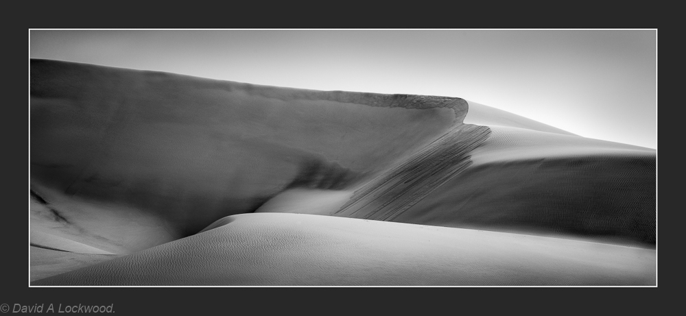 Dunes with wind-blown sand.
An exercise in Depth of Field Control for fun…… D800 AF engaged – exposure manual & pre-set from Pentax Spotmeter readings.

