 This area is about 12,500 square kilometres (4,800 sq mi).
N.B……. If all the right precautions are taken (if you don’t then it is the survival of the fittest and you deserve to die) because there is not much chance of a rescue and the Bedouin will just think you an idiot!
An area well worth a visit for those wishing to experience the vast stillness of the desert. Unpolluted (unpopulated 🙂 ) fantastic clear night sky, which allows a view of the stars in all their glory ‘without the usual light pollution’ and a stillness which is almost palpable.
From that well-known on-line encyclopaedia:-
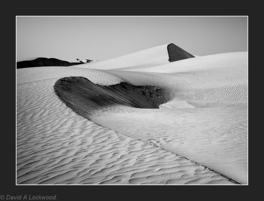
This desert was formed during the Quaternary period as a result of the forces of south-west blowing monsoon and the northern shamal trade wind, coming in from the east. Based on the types of dunes found in the area, it is divided into the high, or upper, Wahiba and low Wahiba. The upper area contains mega-ridge sand systems on a north-south line that are believed to have been formed by monsoon. The dunes of the north, formed at some point after the last regional glaciation, measure up to 100 meters (330 ft) high, with peaks accumulating in the areas just beyond the strongest wind speeds, where declining velocity wind deposited sand. The north and west boundaries of the desert are delineated by the fluvial systems Wadi Batha and Wadi Andam.
Beneath the surface sands are an older layer of cemented carbonate sand. Alluvium deposits believed to have originated from the Wadi Batha during the Palaeolithic era have been disclosed in the central desert 200 meters (660 ft) beneath the inter-dune surface. Wind erosion is believed to have contributed to the existence of a nearly level plain in the south-west.
 A follow-on from my earlier post of ‘Early morning light’ this greeted me one morning ! not a pleasant sight, it means everything gets a coating of sand, so no breakfast until it passes.