Three new archive pages added: click on image to enter, each page has an embedded slide show: just click an image.
 Miscellaneous images portfolio.
 Desert images portfolio.
 Colour images portfolio.
Three new archive pages added: click on image to enter, each page has an embedded slide show: just click an image.
Miscellaneous images portfolio.
Desert images portfolio.
Colour images portfolio.


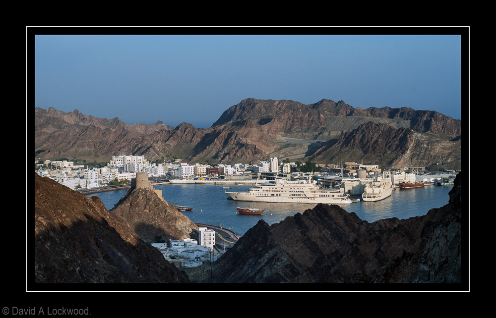
 The white tower like structures on some of the roofs are water containers: a truck arrives every couple of days with a delivery.
In the past, water was obtained the hard way! either a dug well or mountain run-off, a small wall would be constructed near a fissure in the rock and the water trapped for later use.
With the construction of roads (rather than Donkey tracks) along with electricity: life has become a lot less arduous.
 Do not ask me what type because I don’t have a clue…. wanted to see what both the D800 and the 35mm f1.4 made of the exposure extremes – very well!
There is a slight levels adjustment in PS6 otherwise this is how it came out of the camera. Ho and the flower was about 2″ across, so even very close focusing at about f6 also worked. For a film advocate, this would have needed good incident metering and careful choice of film stock; I am getting converted 🙂
 Early morning visit: Wadi Bani Kharus (04:30 alarm clock goes off and no turning over and saying I’ll do it next week) 😉
I escaped early this morning for a visit to Al Elya village in Wadi Bani Kharus. The first time I have been back since a new black-top road was completed from Al Awabi to the village of Al Alya. (did go recently and look at what had been done to the 200 year old Awabi fort since it has been renovated: it’s now actually a new fort built in the style of the old) ho well; I suppose the Ministry of Heritage & Culture know what they are doing. It’s a nice fort but no character and the old one was rather dilapidated so can’t have the tourists hurting themselves.
I must admit that the road makes the journey a lot easier, although far less fun……..
This Wadi is time travel: 600 million years of it in terms of geology; the deeper you go, the older the rocks get.
 Yes I have ridden one 🙂
Rajaz: released by Camel in 1999 with a timing signature composed on the camel’s walking metre.


 Early this morning – hence the haze: humidity is beginning to return! summer will soon be back with a vengeance.

 Nikon D800 – AF-S Nikkor 35mm f1.4G.
(As usual – where do I find a straight line!)
Another early morning impromptu trip.
Rustaq: once the capital of Oman, during the era of Imam Nasir bin Murshid al Ya’arubi. (The one that suggested in 1620 that the Portuguese should leave Oman – he gave them an offer they could not refuse! by 1650 they were all gone and if the Omanis had their way; never to be seen again)
Rustaq Fort: originally known as Qalat Al Kisra was constructed in the 13th century. Recently refurbished, like many of the more significant forts in Oman.
It has a wall around the inner castle (similar to ‘Norman’ construction in the UK) A falaj runs through the fort to supply water for the inhabitants. Should this become contaminated, they were able to rely on a well, giving them the ability to withstand a long siege. One feature of Rustaq Fort is its four watchtowers: Al Burj Al Ahmar (The Red Tower); Al Burj Al Hadeeth (The Modern Tower); Al Burj Al Reeh (The Wind Tower); and Al Burj Ashiateen (or The Devil’s Tower).
More images to follow 🙂

“We are now cruising at a level of two to the power of twenty-five thousand to one against and falling, and we will be restoring normality just as soon as we are sure what is normal anyway.”
Douglas Adams, The Hitchhiker’s Guide to the Galaxy
In the meantime:-
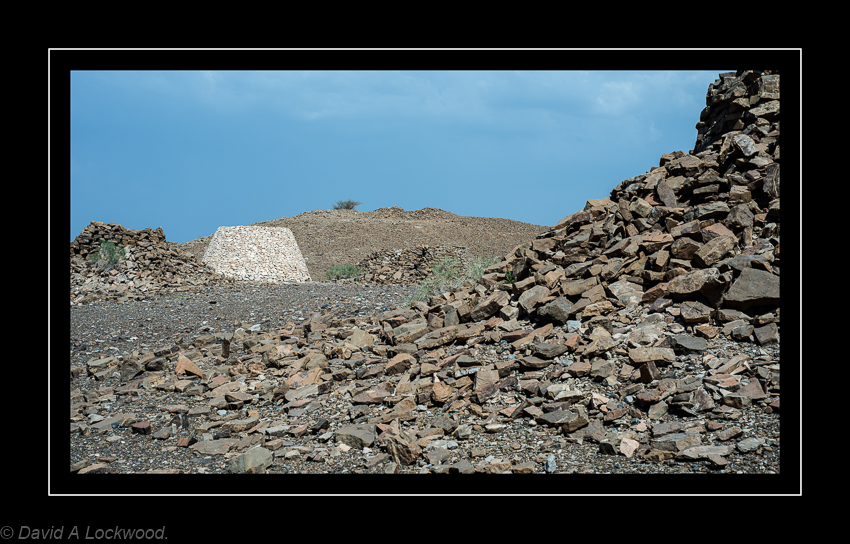
Burial Tombs near Bat: the white one is how they would have looked when in use. It was reconstructed by archaeologists to give an idea of the impressive visual image created, when first seeing them on the surrounding hills.
The Ibri region is very rich in necropolis and archaeological sites dating back to around the third millennium. The village of Bat about 30 kms east of Ibri, appears to have been occupied continuously for well over 4000 years. This type of tomb does not seem to have been collectively used but rather, contained between two to five distinct burial sections.
 Nikon D800 – Nikon AF NIKKOR 50mm f/1.8D.
On the Salalah to Nizwa road.
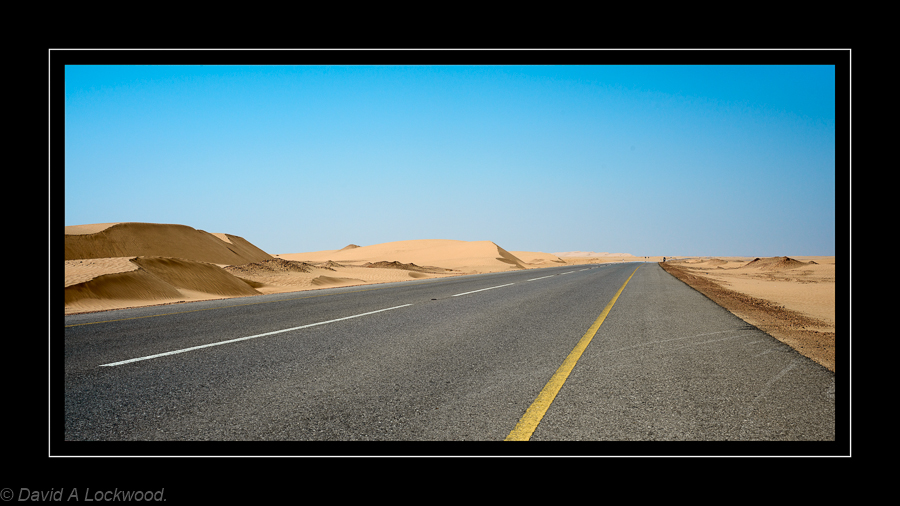
 This is a new-ish road from the Masirah turn off on the Sinaw/Duqm road to the Nizwa/Salalah road. There was always a sand track that the Bedu used (precarious due to movement of sand covering the track) but recently made hard-top.
 Innerdale Monument.
From an account by Tommy Hazell Saltford, Bristol.
In 1943 a group of airmen built the monument on the North-East tip of Masirah near the airfield. It commemorates the massacre of the captain and 21 crew of S.S. Innerdale, a vessel of 3,340 tons, that had run aground on the Kuria Murile islands on 2nd August, 1904. The party left their lifeboat seeking help, and probably thought they had landed on the mainland. A tragic misunderstanding with the natives resulted in the deaths of captain and crew. The ship’s boy was the only survivor. The ringleaders were later executed by the Sultan of Muscat’s forces. The inscription on the monument was misspelt “Inverdale”, and seems to add a unique touch to an unusual piece of history.
A more official account:
The only survivor was a cabin boy who was taken aboard the Dalhousie. Whether the captain had deliberately decided to land, or had simply been driven ashore by the monsoon will never be known, but it appears that on landing, the crew were met by the local sheikh. The Arabs were friendly at first, but at some stage in the proceedings one of the crew fired a pistol. Whether the crew feared for their safety in some way or there was simply an accident cannot be ascertained, but in the resultant fight twenty-one of the seamen were killed. The Arabs buried the bodies in the sand near Ra’s Qudifah, close to the Northern most point of the island. The ringleaders were later captured and punished; some received the death penalty and were also buried on the Northern tip of the island
 I have spent the last week travelling (for work) but it did have its good points, the above beach being one of them 🙂
Masirah – an island off the East coast of Oman.
 D800 with 80-200 Nikon f2.8 AFD lens.
Early morning sunshine with Jebel Misht in the background.
 D800 with 80-200 Nikon f2.8 AFD lens.
Hilltop tower in Wadi Al Ayn.
 Tombs from the 3rd millennium BC.
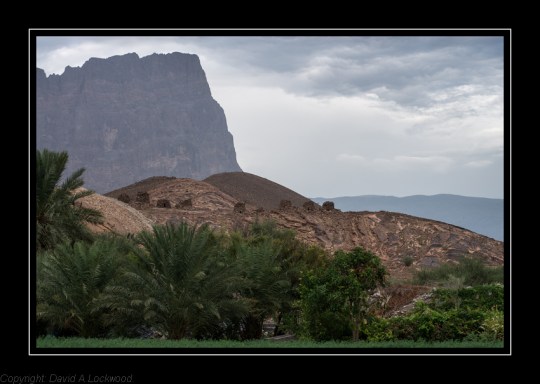 Nikon D800: 80-200 f2.8 Af Nikkor D with mono-pod.
Tombs near Al Ayn (not to be confused with the oasis village of Al Ain in the UAE) Jebel Misht in the background.


These are from a number of images I have yet to process from a trip I took, looking for Neolithic structures near Ibri.
Most of the well known monuments (for want of a better description) are mentioned on the UNESCO site but, the place is littered with structures. Unfortunately, this being Oman, there is very little information or even road signs to guide the tourist.
I decided that I would take a short-cut through the low hills on the approach to Ibri from Muscat, mistake !
I was lost within about half an hour, lost is probably a bit strong, more a case of ‘ha now where do I go’ GPS is no good in cases like this (It just confirms you are lost) so rummage in my map store and find an old 1970’s OS for the area. Compass in hand and good old mark one eyeball along with a quick tentative check on the fuel tank……
I did find some fascinating rock formations though and eventually arrived at my planed destination.

Nikon D800 with 50mm f1.8 Af D.
It was raining when I made this ! and in less than 5 minutes I was back in the car with the wipers going.
Tombs at Halban: an impromptu trip that I took this morning (early 06:30 ish) well that’s early for me 🙂
Halban is about 40 mins. drive from where I live, I was awake (don’t know why – especially on a day off ! ) so thought I would beat the heat of the day.


A little about the tombs at Halban.
The small tombs (there are lots!) found in Oman are generally assumed to date from around the Hafit Period of (3200-2600 BC). They originally had a similar appearance to a beehive, enclosing a small chamber for burial.
Archaeologists believe that the larger tombs found at such sites as Halban, date from the Umm al Nar period in the Bronze age, circ; 2700-2000 BC.. The Umm An-Nar Culture is one of the most important periods in neighbouring UAE, notably Bahrain.
See this link for more:
From archaeological evidence it is suggested that trade in copper with Mesopotamia and the Indus Valley gave rise to the wealthy land known as Dilmun, thought to be in Bahrain. Obtaining copper from the Land of Magan, now largely identified with the ancient copper mining areas in Oman and the adjoining area of UAE. The presence of copper ore in the hills near Halban again points to the link with copper and an Umm Al Nar period.
During the early 1950s, Danish archaeologists excavating grave mounds in Bahrain, found 4,000-year-old settlements and temples thought to be Dilmun, known as the city of the gods in ancient Sumerian literature. Their 1959 discovery on the island of Umm an-Nar near Abu Dhabi of another, previously unknown culture contemporary with Dilmun was unexpected. At this site an outer wall enclosed circular graves, between 15 & 40 feet in diameter with a tower like appearance; in which as many as 25 to 30 people could be buried.
Encouraged by the discoveries at Dilmun and Umm an-Nar; Danish archaeologists excavated 200 single-chambered burial cairns near Jebel Hafit on the Oman-United Arab Emirates border. Here they discovered a culture earlier than both Dilmun and Umm an-Nar. Excavations yielded jars with geometric designs painted in black, white, and dark red, copper and bronze pins along with stone beads. The jars were the same type as used in southern Mesopotamia around 3000 B.C. One problem though; unfortunately there seems to be little trace of the ancient settlements that should accompany these tombs.
The Umm al-Nar tombs are circular and their outer walls were faced with well-shaped smooth stones in a spiral construction. Internally they were mostly divided into a number of chambers, these being used for collective burial. Probably by a family group or members of the same community; who would use them for several generations. In some, archaeologists found the remains of more than 100 people buried in one tomb.
In Oman these tombs have only recently been ‘investigated’ by the outside world (1991 or there about) although when one asks the locals, they will tell you they have always been there and if lucky, will follow this up with “would you like to see some more”………
Obtained from the Web and various publications I have; therefore any errors in the above are down to me………
More links:

Husn Al Heem (Nakhal Fort)
Nikon F4 & Micro-Nikkor f 4 AI 200 mm lens (That is not a misprint, it functions very well as a telephoto lens as well as a macro) T-max 400 @ 320 in T-max developer 1+4.
Husn Al Heem (Nakhal Fort) The origins of which probably date to pre-Islamic times, the structure being continuously remodelled over the centuries; this included a substantial rebuild in the mid-seventeenth century. The present gateway and towers were apparently added about 1834 during the reign of imam Said bin Sultan.
It would seem debatable when Nakhal (or Nakhl ) had its first fort at this location, but there is growing evidence that there has been some sort of fortified structure on the rocky outcrop for a very long time. So it is not inconceivable that it was strengthened or remodelled during the Ya’aruba Dynasty.
The Ya’aruba Dynasty (1624 – 1744): Ya’aruba Imams introduced a period of renaissance in Oman’s fortunes both at home and abroad, by uniting the country and bringing it a great deal of prosperity. It was under the Ya’aruba dynasty that many of the imposing castles in Oman were built.
This is what some of the fort looked like before the substantial refurbishment was started in about 1990.
 The above is made from a similar position to the one in the previous post – Traditional Omani Fort.
 Unfortunately this has a slight colour cast in the sky: this is an old Kodak C41 negative processed by a local shop as I did not have the means to do it my self in those days. could probably remove in Photoshop but hay-ho……..
I am not sure why there is this desire for what is substantially a rebuild; even if all the materials and building practises follow the old traditional ways. but it does generate a lot of interest from visitors so maybe it is just me.
I tend to think castles should be stabilised and left as they are, such as is the case in the UK with the ones mostly built by that ‘Jumped-up Norman’
 Nikon D800 50mm f1.8D lens.
 Nikon D800 50mm f1.8D lens.
