 Nikon Df with Nikkor 35-70 Ai f3.5 zoom.
A colour version of the previous ‘two chairs’ image, before I got a bit carried away with Nik Silver Efex. If you don’t play, it’s not fun.
Nikon Df with Nikkor 35-70 Ai f3.5 zoom.
A colour version of the previous ‘two chairs’ image, before I got a bit carried away with Nik Silver Efex. If you don’t play, it’s not fun.
 Moon above trees
 Early morning with the ducks.
 From my files.
In the foothills of the Ḥajar Mountains there are many tracks that have probably been in use since the Bronze Age if not before, quite a number are still well-trodden to this day. They would follow a Falaj (water channel) system to its source or between two villages and could quite often be several kilometres long.
This is the sort of view that would usually tell me it’s time I turned back, although sometimes if determined enough, I would take my boots off and wade. When the route I was following had a definite final destination and the water was not very deep, then wet I would get !! Quite often I would have been walking for 3 or 4 hours and if I wanted to find an abandoned village or the possibility of rock art, I would only have to make a return journey. Not being able to mark ‘done’ on my list, other than because it was just not possible to overcome an obstacle, would not satisfy my curiosity.
 Memories of warmer weather in Somerset.
 Garden ferns.


The above image shows an example of Witch markings or hexfoils found on the entrance to St Michaels Church Clapton in Gordano Somerset.
People would scratch specific symbols as an act of devotion or to invoke good luck – these symbols would often take the form of a daisy wheel, or hexfoil, a pattern with endless lines. hopefully to confuse and entrap evil spirits.
Similar patterns can be found on doors in a lot of the abandoned villages I visited in Oman and used for exactly the same reason: they would invoke good luck and well-being for the family or ward off evil or malevolent spirits (Jinn).
Those found in Britain come from a time when a belief in witches and superstition was part of everyday life. People constantly sought protection from evil spirits that might entrap them or cause harm to family or livestock.
They are found in churches, Chapels, cottages along with agricultural buildings and were used from medieval times right upto the 18th century. The oldest so far found in UK (as far as I know) are mid 13th century examples on door frames at Donington le Heath Manor House in Leicestershire.
The Church of St Michael Clapton in Gordano, Somerset, England, dates from the 13th century, although the 12th-century tympanum (semi-circular or triangular decorative wall surface over an entrance, door or window) is the oldest visible part of the church, the majority of the building is from the 13th century.
Unfortunately I was unable to visit the inside, I needed to request a key from the custodians as it is no longer a fully active church; a return visit is a must.
 The Grwyne Fawr river Wales No3.
 The Grwyne Fawr river Wales No2
 The Grwyne Fawr: a river in the Brecon Beacons National Park South Wales.
A very enjoyable day trip on a nice sunny day (rare this last few months) while visiting my Daughter in Somerset.
We visited deepest darkest Wales and decided some exploring near Abergavenny was in order. There was an ulterior motive; a search for a house I lived in for a short time when knee high to a Grasshopper.
I had a memory of a river, Dam and heading away from Abergavenny, but no names other than it was near a place called Forest Coal Pit. The river was in a valley on the right hand side going towards the dam. Out came the O.S map of the area and after following a few very ! narrow roads, found it and now know the name of the river again – Grwyne Fawr.
Here in UK over the last couple of days it has been quite warm. It is probably what was called summer when I last lived here, but you wouldn’t think so listening to the dire prognostications coming from the various news outlets.
This is what hot looks like:
 The Huqf – Oman. from my files.
See this link from the Geological Society of Oman: The Huqf.
The Huqf area is a special one for geologists because there are rocks to look at from almost all of Oman’s geological history. This is possible because of the Huqf’s location near the eastern edge of the Arabian Plate which has kept it up-lifted through long periods of geological time.
The oldest rocks in the area are dated using mineral isotopes at about 730 million years. These are basement rocks, a type of granite, which formed deep within the earth’s crust from molten rock. Granite is a type of igneous rock. As the years went by, the basement rocks became covered in layers and layers of rocks, each layer being younger than the one before. These rocks that are made up of lots of fragments of weathered rock or shell fragments, are sedimentary rocks. Often they have fossils or features which give clues about how they formed.
The Huqf area has not always been a desert. At one time, about 300 million years ago, the rocks show evidence that ice sheets covered the area. At other times, it was under a shallow tropical sea. The layers left behind by these seas often contain fossils, but the fossils vary a great deal over time. The oldest fossils are mound structures made by mats of algae, which are called stromatolites. Younger fossils include wonderful tropical shells, such as the rudists bivalve. At yet another time, the area was fairly arid, but with big rivers flowing through. Fossil soils and trees occur in these layers. Each type of climate left behind its own particular pattern of layers of rocks which geologists interpret by looking at what goes on today in places with a similar environment.
In the 1950s, geologists began to study and map the region. They used their understanding of the fossils and rock layers present in the Huqf to help them drill for oil at Fahud, Ghaba and Haima. They found that the rock layers which produce oil from deep below the ground, are the same as those that can be seen at the surface in the Huqf area. So when oil company geologists want to understand the characteristics of the layers of rocks that make up an oil or gas reservoir, they often visit the rocks in the Huqf. Other geologists and students from Sultan Qaboos University and other universities around the world also visit this area with its fascinating geology.
 Chinese ceramics Nakhal fort Oman: from my files.


An enjoyable afternoon watching jousting.
Jousting is a martial game between two horsemen wielding lances with blunted tips. Each participant trying hard to strike the opponent while riding towards him at high speed. The objective being to break the lance on the opponent’s shield or unhorse him.
We were very luck because although the weather was somewhat overcast, there was no rain, even though the going was rather soft from the previous days rain, it did not seem to upset the horses or riders.
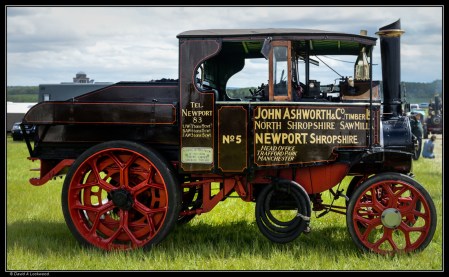 Another fine old workhorse.

 Visited a traction engine show at Castle Howard a couple of days ago, unfortunately the weather was dull and damp (in fact there was a veritable deluge a few hours after I made these) such is UK weather.
 Castle Howard between rain showers, its been a very wet May.
From that well-known encyclopædia:-
Building of Castle Howard began in 1699 and took over 100 years to complete to a design by Sir John Vanbrugh for the 3rd Earl of Carlisle. The site was that of the ruined Henderskelfe Castle, which had come into the Howard family in 1566 through the marriage of Thomas, 4th Duke of Norfolk to Elizabeth Leyburne, widow of Thomas, 4th Baron Dacre. For the Duke of Norfolk’s son Lord William Howard had married his step-sister Elizabeth Dacre, the daughter of the 4th Baron Dacre who brought with her the sizeable estates of Henderskelfe and Naworth Castle as well.
The house is surrounded by a large estate which, at the time of the 7th Earl of Carlisle, covered over 13,000 acres and included the villages of Welburn, Bulmer, Slingsby, Terrington and Coneysthorpe.The estate was served by its own railway station, Castle Howard, from 1845 to the 1950s.
 Nature at its most delicate.
 Just to show that summer is on its way here in Driffield.
 From my Oman files.
Fossil records show the date palm has existed for at least 50 million years.
Dates have been found on a number of neolithic sites, which would suggest that they were being eaten as much as 7,000 to 8,000 years ago.
They provide a range of essential nutrients, and are a good source of dietary potassium. The sugar content of ripe dates is about 80%; the rest consists of protein, fibre, and trace elements that include boron, cobalt, copper, fluorine, magnesium, manganese, selenium, and zinc.
Oman has more than 250 varieties of dates, and each region of the country will tell you theirs are the best. But I think of all, it has to be the ‘Khalas’, found in the Sharqiya and Dhahirah region, also Al Rostaq. The fruit is bright yellow, oval-shaped, and usually eaten fresh or half-dry.
Dates and qahwah arabiyya (coffee) is a fundamental part of Omani hospitality; even the poorest family will offer coffee & dates when one visits.
 Back to Oman from my files of 2016, even if only as a reminder of what it was like without constant rain.
 Before sunrise & in the opposite direction from the earlier post I made.
This from wikipedia & English Heritage.
Geophysical work by English Heritage in 1997 revealed a surrounding ditch and nine concentric rings of postholes within the stone circle. More than four hundred pits, 1 metre (3ft 3in) across and at 2.5 metres (8ft 2in) intervals, stood in rings at the site. The ditch is 135 metres (443ft) in diameter and about 7 metres (23ft) wide. A 40 metres (130ft) wide entrance was visible on the north-east side. No surrounding bank has been identified although the site awaits excavation.
The geophysical work transformed the traditional view of Stanton Drew as being a surface monument and the Great Circle is now seen as being one of the largest and most impressive Neolithic monuments to have been built. Analogous with the circles of postholes at sites at Woodhenge, Durrington Walls and The Sanctuary, it is thought that the pits would have held posts which would have either been freestanding or lintelled as they could not have supported a roof at that size. The postholes in nine concentric rings held posts up to 1 metre (3.3ft) in diameter indicating the use of ancient trees which were sacred to the druids.
Nearby and to the north-east is a smaller ring of eight stones in the centre of which the geophysical work identified four further pits. A third ring of twelve stones, measuring 43 metres (141 t) wide, stands to the south-west.
The Cove.
A fluxgate gradiometer survey in July 2009 investigated standing stones in the garden of the Druids Arms public house known as The Cove, which showed that the stones date from nearly a thousand years before the stone circles. The conclusion from the study was that these upright stones are likely to have been the portals or façade of a chambered tomb.
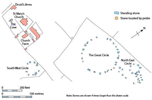
 Stanton Drew stone circles in the county of Somerset England.
Just had a very enjoyable long weekend with my daughter, this was one of the
places we visited.
Probably late Neolithic to early Bronze Age: thought to date between 3000 and 2000 BC. I will post more in the next few weeks.
See this link from English Heritage: Stanton Drew.
 Nikon Df with 43-86 Ai zoom lens.
Reaching out for other trees: not so strange as it may sound, there is research going on that seems to confirm that trees actually do communicate with each other.
See this link from the Smithsonian: Do Trees Talk to Each Other?
 Nikon Df with Nikkor 35-70 f3.5 Ai zoom lens.
Another short walk while the sun was out and before the last of the
snow turned into sludge.
This is about 5 minutes walk from our house and my aim is at least one image a month, that way I should capture all the seasons of the year. So far I’ve managed Fog, rain, snow and even some sun, although that can be a rare commodity at this time of year.
 Tree Stump & moss.
Nikon Df with Nikkor 35-70 Ai f3.5 zoom lens. This lens dates from the early 1970’s and takes 72mm filters – changed to 62mm when the Ais version was released and continued in production until 1987. My lens has ones of those nice metal screw in lens caps, much nicer that the now ubiquitous plastic things.
