 Jebel Shams – village.
Tag: Shams.
Jebel Misht.
 View of the great ‘exotic’ Jebel Misht: “Comb Mountain” because of its jagged ridges.
Another route that I travel for work and during this time of year; camping trips so that I can get away from the heat.
Unfortunately with images made during the summer months, it is very easy to see the different layers of pollution, sand & dust that
get trapped due to the heat.
Dead tree – blue tone.
 Dead tree – blue tone Jebel Shams.
Dead & Alive.


Dead & Alive.
Mountain road.
 Mountain road – when I drive this route it’s mostly work related: well someone has got to do it 😎
Wild Olive – Jebel Shams.
 Wild Olive – Jebel Shams @ about 7500ft.
Return from Jebel Shams No2.
 Fuji X-pro1 with XF. 27mm f2.8 lens.
A very wet & slippery road – 4×4 in low ratio is a must ! as this was made at about 9000ft.
Return from Jebel Shams – A wet day !
 Fuji X-pro1 with XF. 27mm f2.8 lens.
A few days work at Jebel Shams last week – on the day of return it was fog & rain….. again.
Old chemicals & film – not always a good mix !
 Made at about 9600ft early one morning on my Yashica 124G: using old Kodak Ektachrome sw 100 6×6 film.
Found in the back of my freezer…. age, no idea because the outer box was missing – but old ! which is why it got overlooked (well that’s my excuse anyway) I will not mention the box of old developer used.
There is some unevenness seen in the sky (like bromide drag) probably more chemical related than film. But hay-ho, it is always fun not being really sure what will come out of the tank. At least it wasn’t a completely clear strip of emulsion with a glutinous mess in the bottom of the tank; old story, as I was trying development of B&w transparencies and got the acid quantity wrong ❗
Geology on display – Shams.
 Geology on display-Shams.
Cairn – Jebel Shams.
 Cairn – Jebel Shams.
I have no idea of its age; always been there, say the locals – there are the remains of early Iron age tombs – see below and (if you know where to look) stone house foundations of probably the same period.

Jebel Misht lost in cloud.
 Nikon F4 with Sigma 28mm f2.8 Ais lens. On Kodak Plus-x.
Tree root in rocks – Jebel Shams.
 Nikon F4 with AF Nikkor 50mm f1.8D. Made on Kodak Plus-X at box speed.
Just as a matter of interest: it’s lashing it down with rain here in Bausher !!! welcome after the heat of the last couple of weeks, but unexpected.
From the top of Jebel Shams.
A few quick snaps while I was waiting for some work to be carried out – taken from the very top of Shams: where the tourists can’t get 😉

It’s a long way down !


Step-off and it’s 9000ft with a few bumps on the way.


Cloud shadows. Step-off this one & it’s more like 10,000ft give or take.

Storm coming in the distance.
Clouds over Wadi Sahtan.
 Yesterdays cloud build-up over Wadi Sahtan – made from jebel Shams.
Dead Tree – Jebel Shams.
 I have made an image of this tree before – several years ago.
It is still standing majestically & avoiding all that time can throw at it.
Old Tree – Jebel Shams.
 I have visited Jebel Shams (work !!) stopped at about 8500ft and took advantage of the cool clear weather.
Talking of weather – I left Muscat with the temperature around 40c. and found the very top of Shams at a comfortable 24c. That last 3000ft makes all the difference – also enjoyed a pleasant interlude of coffee & dates with the guards 🙂
Juniper tree – Jebel Shams.
 The Juniper has done very well this year – lots of new growth, helped by plenty of rain & some snow.
This one is at about 9900ft. Note the fossils in the rocks; from when this area was under the Tethys sea, its come a long way since then.
Foggy day on Jebel Shams.
 Nikon F4. Kodak T.max ISO 400 @ 320.
Back in the dark-room after a nice long (cold, wet & snowy) holiday.
Problems opening theme page.
Problems opening theme page – actually anyone’s WordPress page: very strange as the theme construction is just not there.
Ho well, with luck the ‘Happiness Engineers’ will sort out what is going on: two computers, one win8 the other win7 also a Samsung tab on Wi-Fi, using Firefox or Windows Explorer, all show the same problem.
With luck this post will look ok as preview puts it all down one side of the page, my theme is just not there.
In the meantime here are a few from my favourite mountain:


 Nikon F4 using T-Max 400 @ 320.
Jebel Track.
 Nikon F4 & Tokina 35-70 f2.8 AIS AT-X, made on Ilford fp4. Negative slightly diffused with Vaseline on old filter.
Another reprint from my archive.
 Nikon F4: T-max 400 at 320. Kodak D76 1+1.
You could be forgiven for thinking this was the Yorkshire moors near where I live when in UK; but it was made on a very wet day at Jebel Shams.
I remember, because there had been a rock fall and a late friend of mine suggested we go and see if it was possible for us to depart the mountain. No such luck.
I was now faced with a trip on a helicopter and that is one form of transport I do not like …! well I also include the C130 (if I wanted to fly those I’d have joined the paratroops) but at least I will get on one if needs must .
But a helicopter at 10,000 ft is pushing the limits………
The Hajar Mountains: جبال الحجر
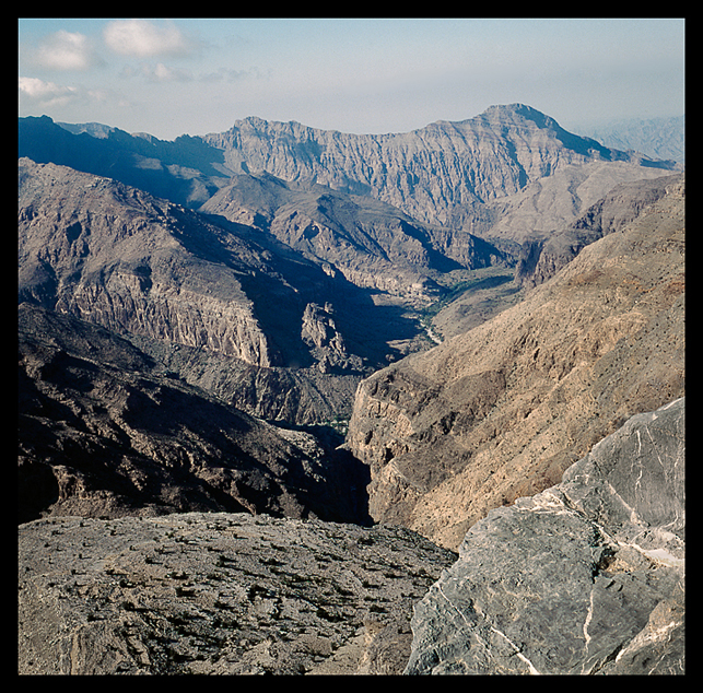 For those interested – this is an indication of the different topography that can be seen when getting up high in the mountains. Made from about 7500ft – note the wadi winding through the valley.
From Wiki:
The Hajar Mountains in north-eastern Oman and also the eastern United Arab Emirates are the highest mountain range in the eastern Arabian Peninsula. They separate the low coastal plain of Oman from the high desert plateau, and lie 50–100 km inland from the Gulf of Oman coast.
The mountains begin in the north, forming the Musandam peninsula. From there, the Northern Hajjar (Hajjar al Gharbi) runs southeast, parallel to the coast but moving gradually further away as it goes.
Sun & Clouds.
 Bronica S2a – Nikkor 50mm f2.8.
Clouds From Shams.
 Nikon F4 Nikkor AF D f2.8 20mm
Made at about 9900ft as the sun comes up.
