 Jebel Misht in sunshine.
Tag: Jebel
Precarious !
 I would not like going for a walk at night ……!
Juniper tree – Jebel Shams.
 The Juniper has done very well this year – lots of new growth, helped by plenty of rain & some snow.
This one is at about 9900ft. Note the fossils in the rocks; from when this area was under the Tethys sea, its come a long way since then.
Sundown.
 Sundown.
Off-Road from Bani Auf.
 Some of the easier off-road driving in Oman – looking toward Wadi Bani Auf.
Jebel Akhdar Village No3.

The Devil’s finger jebel akhdar.
 The setting sun has just dropped behind the range of hills – last night on Jebel Akhdar: the sticky up bit a third of the way in from the left is known as The Devil’s finger.
I have tried along with some friends, to find a path that gets me onto this prominent feature – other than the very long hike from right to left along the range of mountains. Unfortunately without success as yet; it’s the long way or not at all.
It has been raining for the last few evenings on this range of mountains, hence the dark clouds.
Jebel Misht.
 Misht from lower Shams.
Pushing the limits of film & Photoshop images.
Jebel Track.
 Nikon F4 & Tokina 35-70 f2.8 AIS AT-X, made on Ilford fp4. Negative slightly diffused with Vaseline on old filter.
Jebel Village with early morning sun.
 Nikon F4. 80-200 f2.8 AF ED Zoom lens. Kodak T-max 400 at 1600asa (not because I needed the speed; wanted chunky grain) also used an old UV filter with a very small amount of Vaseline on it.
The Hajar Mountains: جبال الحجر
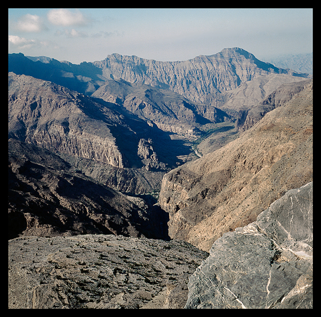 For those interested – this is an indication of the different topography that can be seen when getting up high in the mountains. Made from about 7500ft – note the wadi winding through the valley.
From Wiki:
The Hajar Mountains in north-eastern Oman and also the eastern United Arab Emirates are the highest mountain range in the eastern Arabian Peninsula. They separate the low coastal plain of Oman from the high desert plateau, and lie 50–100 km inland from the Gulf of Oman coast.
The mountains begin in the north, forming the Musandam peninsula. From there, the Northern Hajjar (Hajjar al Gharbi) runs southeast, parallel to the coast but moving gradually further away as it goes.
A Deep Pool in the Mountains.
 Bronica S2a – Nikkor 50mm f2.8. Kodak E200sw.
Sun & Clouds.
 Bronica S2a – Nikkor 50mm f2.8.
Jebel Fortified House.
 Nikon F4. 50mm f1.8D & Kodak E100vs.
Clouds From Shams.
 Nikon F4 Nikkor AF D f2.8 20mm
Made at about 9900ft as the sun comes up.
Storm coming over Jebel Misht.
 Yashica 124G – negative slightly cropped.
One thing that can be said about Jebel Shams is that the weather never fails to impress, although getting the right exposure can be a real pain sometimes…. 🙂
I will not go into the scanning problems.
Rock Detail No2.

Rock Detail.
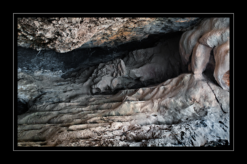
Detail from inside a very deep overhang Jebel Shams.
Nikon D200 (Fill flash) Tokina AT-x 35-70 f2.8 Ais lens.
In for a wet night !

Jebel Shams toward Jebel Misht.

Jebel Shams – trees.
 Cluster of trees on the Jebel Shams route.
Rock Formations.

Rock Formations – Jebel Shams.

Early Evening – Jebel Shams.

Tree & rocks.

